
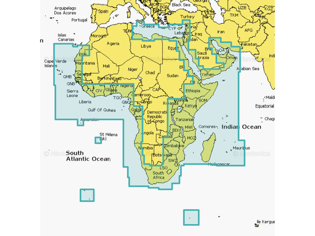
NAVIONICS PLATINUM AFRICA AND MIDDLE EAST. Coastal coverage of the coast of Africa from Tripoli, Libya thru the Red Sea and around the Cape to Dakar, Senegal including the Suez Canal and the Levant, the coast of the Arabian Peninsula, the Persian Gulf, Madagascar, Socotra, Zanzibar, Reunion, Mauritius, the Seychelles, the Comoros, the Prince Edward Islands, Tristan de Cunha, St Helena Island, Ascension Island, the Cape Verde Islands, Malta and Cyprus. Coverage of ports such as Alexandria, Egypt; Djibouti; Manama, Bahrain; Dubai; Cape Town, South Africa and Lagos, Nigeria are included.
| Code | Unit | PRICE |
| 1019041 | 1 x Unit | NO STOCK |
NAVIONICS PLATINUM AFRICA AND MIDDLE EAST
Coastal coverage of the coast of Africa from Tripoli, Libya thru the Red Sea and around the Cape to Dakar, Senegal including the Suez Canal and the Levant, the coast of the Arabian Peninsula, the Persian Gulf, Madagascar, Socotra, Zanzibar, Reunion, Mauritius, the Seychelles, the Comoros, the Prince Edward Islands, Tristan de Cunha, St Helena Island, Ascension Island, the Cape Verde Islands, Malta and Cyprus. Coverage of ports such as Alexandria, Egypt; Djibouti; Manama, Bahrain; Dubai; Cape Town, South Africa and Lagos, Nigeria are included.
CARD TYPE
| Navionics+ | Platinum+ | |
|---|---|---|
| Coastal Content | • | • |
| Inland Content | 42,000+lakes | 42,000+lakes |
| Detailed Nautical Charts | • | • |
| SonarChartTM HD Bathymetry | • | • |
| Daily Updates1 | • | • |
| Dock-to-dock Route Guidance 1,2 | • | • |
| Plotter Sync1 | • | • |
| Community Edits | • | • |
| Advanced Map Options1 | • | • |
| SonarChartTM Live Mapping3 | • | • |
| High-resolution Relief Shading1 | Via Chart Installer | |
| Satellite Imagery with SonarChartTM Shading Overlay1 | Via Chart Installer | |
| Sonar Imagery1 | Via Chart Installer | |
| Aerial Photography | • | |
| 3D View
|
DISCLAIMER: THE PICTURES SERVE AS A GUIDE ONLY AND MAY NOT BE AN ACCURATE REPRESENTATION OF THE PRODUCT IN STORE.
THIS PRODUCT HAS BEEN VIEWED 1256 TIMES SINCE 17 JANUARY 2023